 Germany
  India
India Septième bulletin de cyclone pour Maurice émis à 19h10 ce Samedi 19 Février 2022.
Written by admin on 19 February 2022
French Version
Un avertissement de cyclone de classe III est en vigueur à Maurice
Un avertissement de cyclone de classe III est en vigueur à Maurice
Septième bulletin de cyclone pour Maurice émis à 19h10 ce Samedi 19 Février 2022.
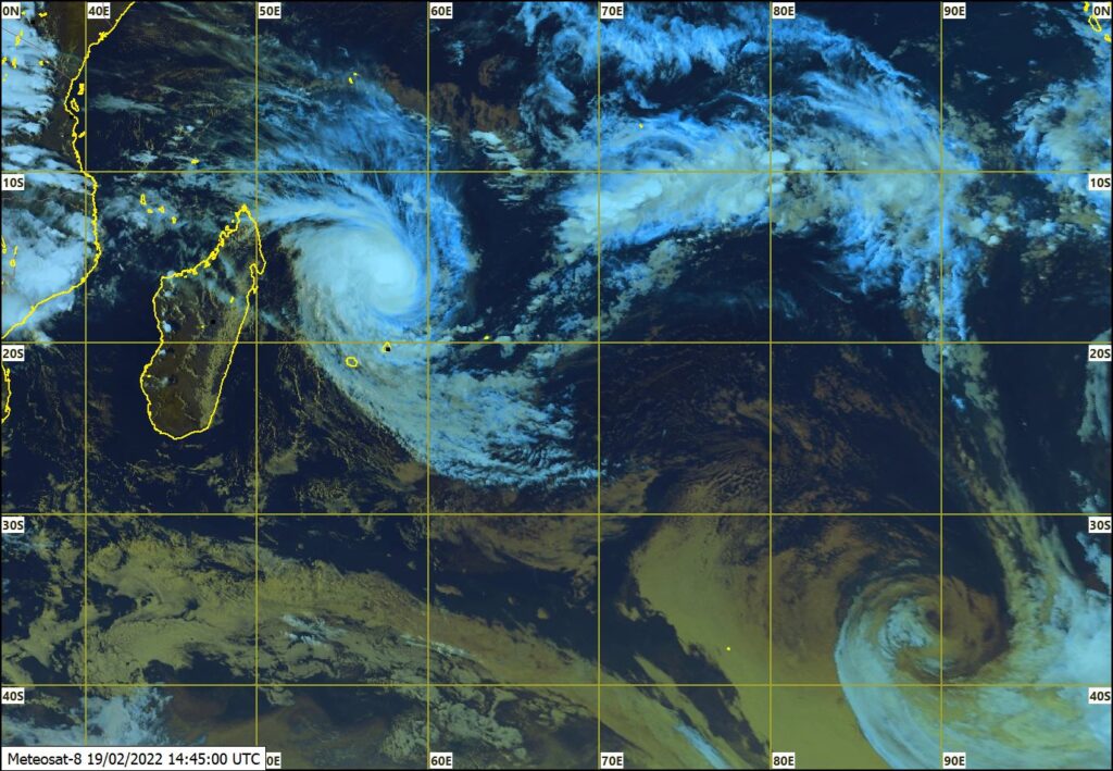
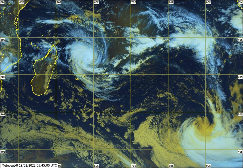
La baisse continuelle de la pression barométrique à Plaisance et le renforcement des rafales confirment la venue du cyclone tropical Emnati. La pression estimée au centre du système est au environ de 965 hPa et les rafales près du centre sont de l’ordre de 180 km/h.
A 1900 heures, le cyclone tropical Emnati était centré à environ 360 km au nord de Cap Malheureux en latitude 16.6 degrés sud et longitude 57.6 degrés est. Le cyclone tropical Emnati continue à se déplacer vers le sud-ouest à une vitesse d’environ 17 km/h.
Sur cette trajectoire, Emnati s’approche de l’île et passera à son point le plus rapproche à environ 275 km au nord-nord-ouest de Grand-Bay demain matin. Des bandes nuageuses actives d’Emnati traverseront l’île de temps à autres et occasionneront de fortes pluies accompagnées de fortes rafales dépassant les 110 km/h. Dans l’éventualité d’un léger infléchissement du trajectoire vers le sud et une légère intensification, la possibilité que les rafales puissent atteindre les 120 km/h existe. De ce fait, le cyclone tropical Emnati représente un danger direct pour Maurice.
Un avertissement de cyclone de classe III est en vigueur à Maurice.
Il est conseillé au public à Maurice de compléter toutes les précautions.
Des bandes externes d’Emnati traversent Maurice occasionnant des pluies intermittentes, devenant modérées à fortes et accompagnées d’orages par moments. Les fortes pluies seront plus fréquentes cette nuit et demain matin.
Le vent soufflera du sud-est à une vitesse d’environ 65 km/h avec des rafales de 100 à 110 km/h avec une probabilité de se renforcer davantage pour atteindre 120 km/h.
La mer sera grosse avec des houles de l’ordre de 7 mètres. Il y a un risque de marée-de-tempête de l’ordre de 1 mètre au nord-est, au nord et a l’Ouest occasionnant une submersion des zones basses dans ces régions a l’heure de la marée montante.
Le public est conseillé de ne pas s’aventurer en mer.
Un avertissement de cyclone de classe III est en vigueur à Maurice.
Un avertissement de cyclone de classe III est en vigueur à Maurice.
Le prochain bulletin sera émis vers 22h10.
English Version
A cyclone warning class III is in force in Mauritius
A cyclone warning class III is in force in Mauritius
Seventh cyclone bulletin for Mauritius issued at 19h10 hours on Saturday 19 February 2022.
Barometric pressure is falling at Plaisance and gusts are gradually increasing, thus confirming the coming of tropical cyclone Emnati. The estimated central pressure of the system is around 965 hPa and the estimated wind gust near the centre is around 180 km/h.
At 1900 hours tropical cyclone Emnati was centred at about 360 km the north of Cap Malheureux near latitude 16.6 degrees south and longitude 57.6 degrees east. It continues to move in a south-westerly direction at a speed of about 17 km/h.
On this trajectory, tropical cyclone Emnati is appoaching the island and will pass at about 275 km to the north-north-west of Grand Bay tomorrow morning at its closest distance. Active cloud bands of Emnati will cross the island now and then, causing heavy rains accompanied with strong gusts exceeding 110 km/h. In the event of a slight recurvature of the trajectory further to the south and any slight intensification of the cyclone, the possibility of gusts reaching 120 km/h exists. Therefore, tropical cyclone Emnati represents a direct threat to Mauritius.
A cyclone warning class III is in force in Mauritius.
The public in Mauritius is advised to complete all precautions.
Outer cloud bands of Emnati are crossing the island causing intermittent rain, becoming moderate to heavy at times with thunderstorms. The heavy rains will be more frequent tonight and tomorrow morning.
Wind will blow from the south-east at a speed of about 65 km/h with gusts of 100 to 110 km/h tonight with a probability of strengthening further and reaching 120 km/h.
The sea will be high with swells of the order of 7 metres. There is a risk of storm surge of the order of 1.0 metre to the north-east, the north and to the west causing coastal inundation in these regions at high tides.
The public is advised not to venture at sea.
A cyclone warning class III is in force in Mauritius
A cyclone warning class III is in force in Mauritius.
The next bulletin will be issued at around 22h10.
Creole Version
Enn warning siklonn klass III en viger lor Moris.
Enn warning siklonn klass III en viger lor Moris.
Setiem biltin siklonn pou Moris ki finn tire a 19h10 azordi samdi 19 Fevriye 2022
La presion barometric pe baisse a Plaisance ek rafal pe ogmante graduelman, seki sa confirme Siklonn tropikal Emnati pe vini. Siklonn Emnati ena enn presion santral anviron 965 hPa ek bann rafal anviron 180 km/h pre kot so sant.
A 1900 er, siklonn tropikal Emnati ti santre anviron 360 km au nor de Cap Malheureux lor latitid 16.6 degre sid ek longitid 57.6 degre es. Li pe kontinie bouz dan enn direksion sid-wes avek enn vites d’anviron 17 km/h.
Lor sa trazektwar la siklonn tropikal Emnati pou passe so point pli raprocher dimin gramatin anviron 275 km au nor-nor-wes Grand Bay. Bann nyaz aktif de Emnati pou travers lil detanzantan ek pou okazione bann gros lapli ek gros rafal ki pou depas 110 km/h. Dan l’evantialite ki ena ene leze inflessisman dan trajectoire ver le sid ek li ine intensifie lezerman, posibilite gagn bann rafal ki kapav arrive juska 120km/h touzour existe. De ce fait, siklonn tropikal Emnati reprezant enn menas potansiel pou Moris.
Enn warning siklonn klass III en viger lor Moris.
Piblik a Moris bisin konplet tou bann prekosion.
Bann nyaz extern de Emnati pe travers Maurice ek li pe okazione bann lapli intermitan ki pou gro par moman avek loraz.Lapli pou pli frequan aswar ek dimin gramatin.
Divan pou soufle depi sid-es a anviron 65 km/h avec rafal 100 a 110 km/h avek posibilite ki li pou ogmante pou arive 120 km/h.
La mer pou extra move aswar avek laoule environ 7 met. Ena risk gagne bann radmare de lord de 1 met au nor-es, au nor ek a lwes ek li kapav gagne inondasion kotie a ler maree ot.
Piblik konseye pa fer bann sorti dan lamer.
Enn warning siklonn klass III en viger lor Moris.
Enn warning siklonn klass III en viger lor Moris.
Prosin biltin pou tire ver 22h10.
Source : metservice.intnet.mu
Last Updated on 19 February 2022 @ 7:23 pm
![]()